
Page by Barry (with thanks to Deb and Mike)
Settlement History — Pennsylvania and Ohio
The modern history of Pennsylvania began in 1681, when William Penn (a Quaker) received a royal deed from King Charles II of England. Pennsylvania was colonized by Swedish and Dutch settlers in the 17th century, before the English took control of the colony in 1667. In 1681, William Penn established a colony based on religious tolerance; it was settled by many Quakers and its chief city, Philadelphia, prospered. In the mid-eighteenth century, the colony attracted many German and Scots-Irish immigrants.
One of these was the founder of McKeesport Pennsylvania – David McKee :
About the beginning of the eighteenth century, David McKee, with his family, moved from Scotland to the Protestant settlement in the north of Ireland, setting near Londonderry. But Persecution followed the Presbyterians and about the middle of the century he was forced to seek a new home. He came to America in company with several bothers and found In the Province of Pennsylvania what he said he long had sought: “a church without a bishop; a state without a king.”
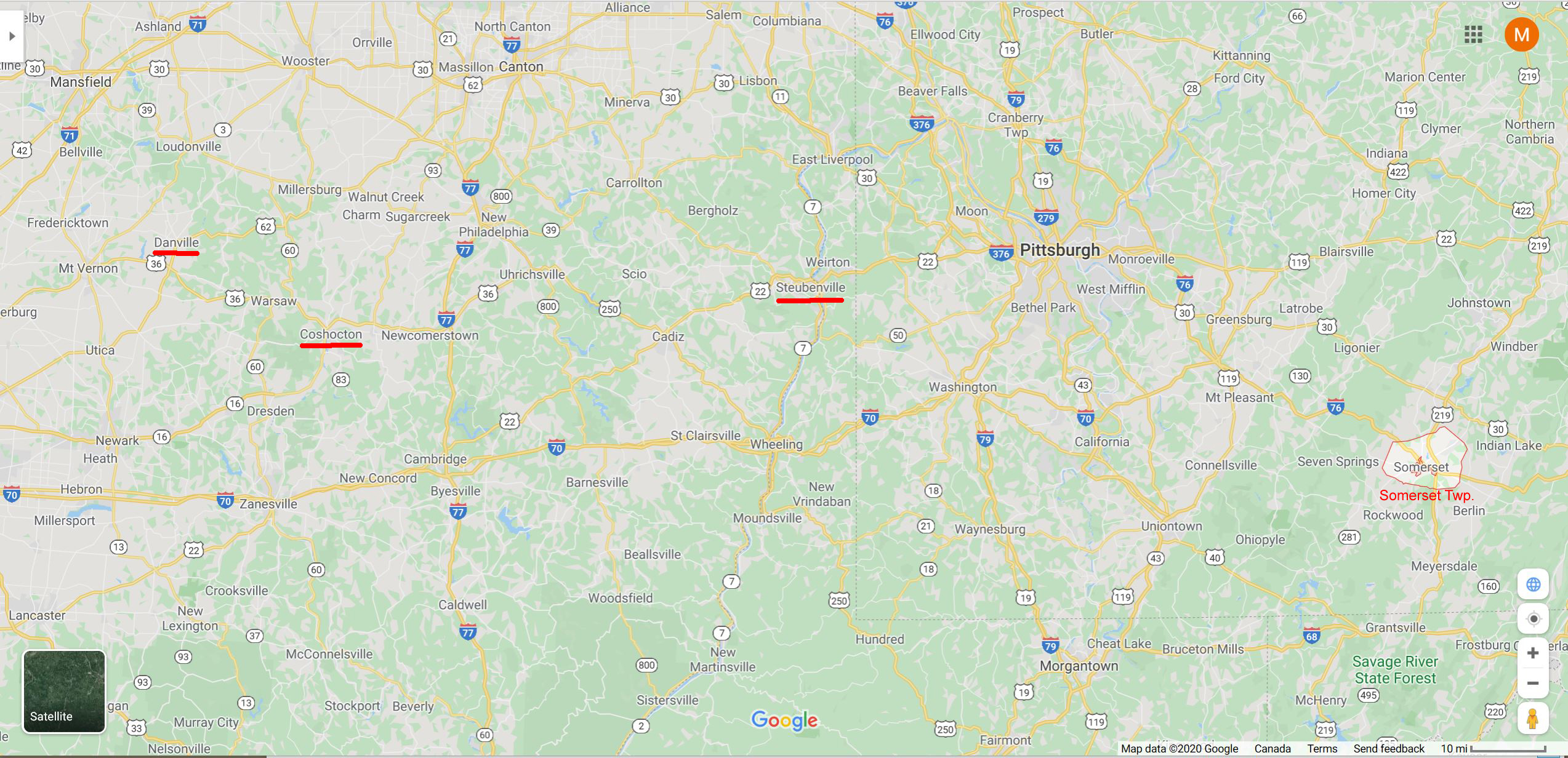
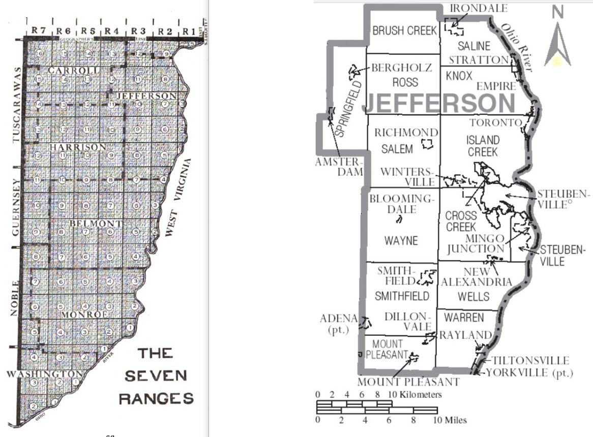
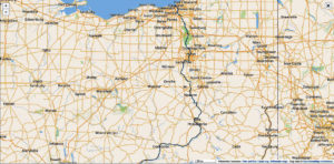
By 1792, one of these Scots-Donegal immigrants was Deb’s gr—gr grandfather Charles McKee. He first settled in Somerset Twp, Somerset County, Pennsylvania, but by 1800 (probably 1798), Charles had moved with his family to Cross Creek Township, Washington County. Pennsylvania. But Deb notes this address is confusing, because this Cross Creek Township was actually across the Ohio River in what later became Jefferson County, Ohio. The modern map here (click to enlarge) shows the western half of Pennsylvania and the eastern half of Ohio. Somerset Twp, Steubenville, Coshocton and Danville are underlined. See also the maps and records in our related webpage Early Settlers in S.W. Pennsylvania.
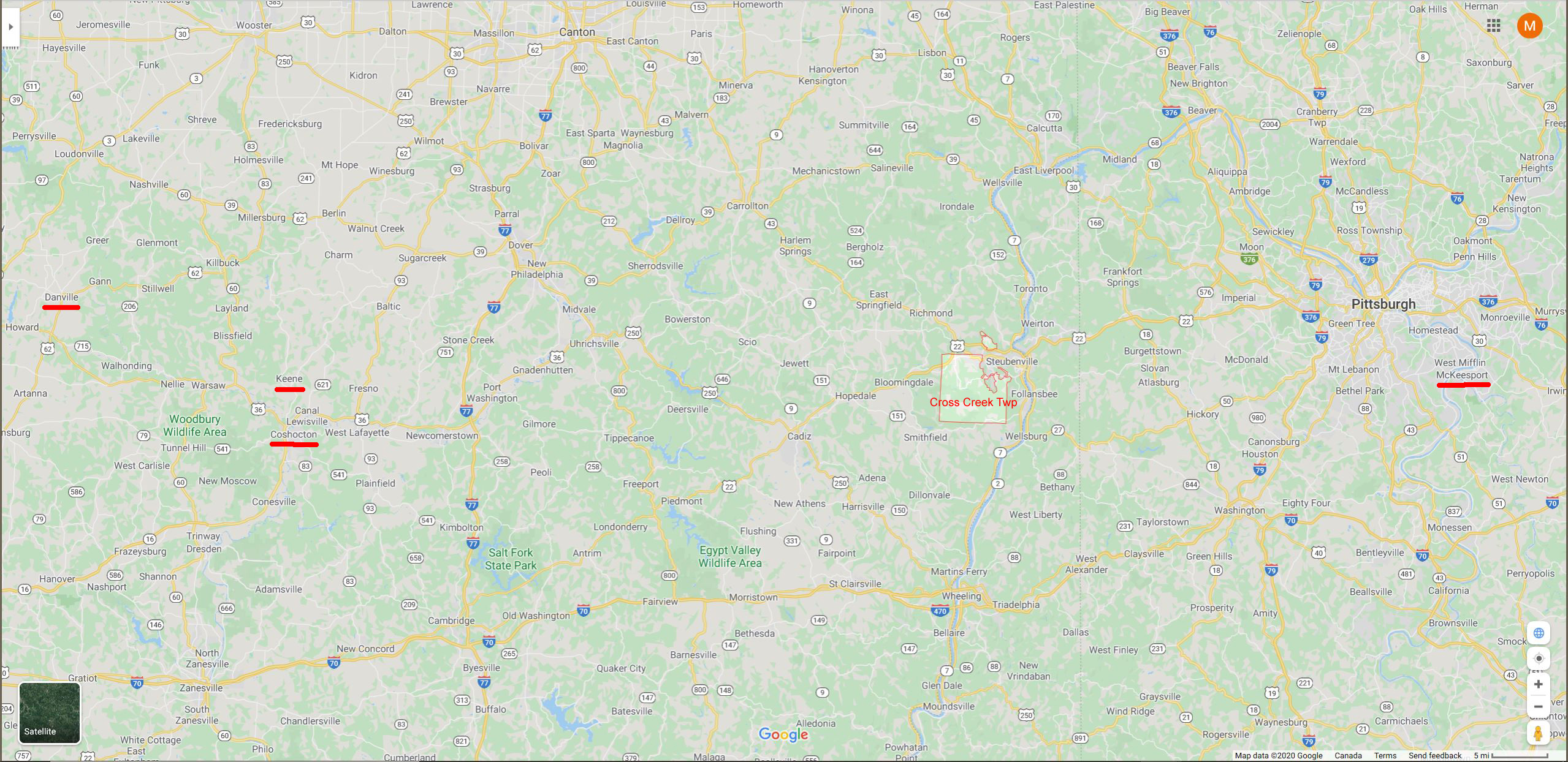
The next paragraph (in italics) is extracted from p 721 History of Washington County, Pennsylvania – Cross Creek Twp. It states that Hopewell Twp. was split to include Cross Creek Twp in 1789 and Cross Creek was further divided in or after 1806 to include Mount Pleasant and Jefferson Twps. But it was 1803 when the state of Ohio was created, so before then Cross Creek Twp. was administered by Pennsylvania. The map below right shows the modern Cross Creek Twp. outlined in red and the “McKee” towns of McKeesport, Coshocton, Keene, and Danville are underlined.
The territory now embraced in the townships of Cross Creek, Jefferson, and part of Mount Pleasant was included in the original township of Hopewell for more than eight years from the erection of the last-named township. The first movement towards the formation of Cross Creek township from a part of Hopewell was a petition to the court, March, 1789. and was confirmed by that body on the 10th of December, 1789, thus creating the township of Cross Creek, and making it a separate justice’s district. The township of Cross Creek retained its original territory and limits until May, 1806, when a portion of it was taken to form the township of Mount Pleasant; and in 1853 the township of Jefferson was formed from the western part of Cross Creek, reducing the township to its present limits.
History of Jefferson County – 1890
There is a lot of Ohio history now available from the web. I found a book which included the early history of Jefferson County, and uploaded it as a PDF File here:
HISTORY OF THE UPPER OHIO VALLEY, WITH FAMILY HISTORY AND BIOGRAPHICAL SKETCHES, A STATEMENT OF ITS RESOURCES, INDUSTRIAL GROWTH AND COMMERCIAL ADVANTAGES. VOL. II. ILLUSTRATED, MADISON, WIS.: BRANT & FULLER, 1890
(Note there are different authors for each chapter)
In this book, I did a search for McKee, and found several entries including a Col. Joseph McKee, Mount Pleasant Twp, Jefferson County:
Excerpt from Ch VI (following p368) HISTORY OF THE UPPER OHIO VALLEY.
CHAPTER VI. — By W. M. Trainer.
ORGANIZATION OF JEFFERSON COUNTY— FIRST TOWNSHIP— ELECTION STATISTICS — ROSTER OF COUNTY OFFICERS CITY OF STEUBENVILLE — OTHER TOWNS OF THE COUNTY—LATER TOWNSHIPS — HISTORICAL NOTES, ETC.
Page 373 – – Representatives. — The following is a list of the representatives to the general assembly of Ohio, since the organization of the state. The first general assembly convened March 3, 1803, and the second on the first Monday in December following: 1803, Rudolph Bear, Z. A. Beatty, Thomas Elliott, Isaac Meeks, Richard Beeson, Samuel Dunlap, Joseph McKee and John Sloan; 1804, Thomas McClure, John Sloan and John McLaughlin; 1805, John Sloan, John McLaughlin and Thomas Elliott; 1806, Samuel Boyd, Thomas Elliott and John McLaughlin;
p 384 — Mount Pleasant Township was organized March 3, 1807, from Short Creek township. In this locality wool-growing and stock-raising have largely taken the place of grain-growing, and the mills have mostly disappeared from the creeks. It is probable that Robert Carothers and Jesse Thomas were the first settlers in Mount Pleasant township. They came from Pennsylvania and settled the land on which the village now stands in 1796 — Carothers on the eastern part and Thomas on the western side. They together laid off the village on this land in 1804. Adam Dunlap also came in 1796, settled on the land now owned by John Weatherson, east of the village. Col. McCune came in 1798, and settled about three and a half miles southeast. This property is now owned by John Weatherson. John Tygart came also in 1798 and settled on adjoining land to McCune. It is now the property of John Parke and Isaac Radcliff. Col. Joseph McKee came about the same time, and settled northeast of Col. McCune, on the farm now owned by Richard Hope. William Finney and Adam Dunlap about 1798 or 1799; settled between Robinson and Dunlap. Aaron Schemerhorn now owns the Finney farm, and Sarah E. Jenkins, the Dunlap farm.
Land Purchase and Sale – 1807 and 1810 – Charles McKee, Jefferson Co., Ohio
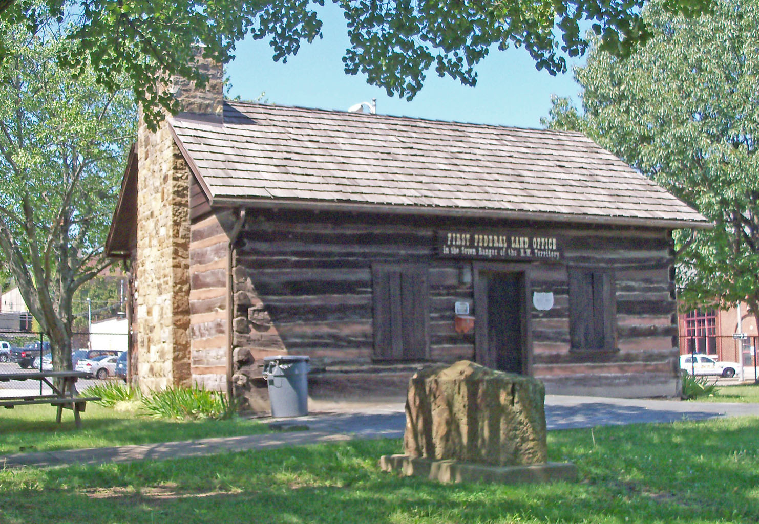
By 1803, North-East Ohio had been surveyed and made available for settlement with the first Government Land Office at Steubenville, Jefferson Co. Mike Barr, a descendant of one of those early settlers in Ohio, points out that the majority of those early Ohio settlers would have been children of settlers in neighboring Pennsylvania looking for more space for farming. Charles McKee took his wife and family with him, for in 1807 there was a land transaction where Charles McKee bought 145 acres in Jefferson County, Ohio. (Section 12, township nine – now Wayne Twp, range 4) for $ 507.50. The photo of this 1807 land deed is shown at left, and the text is transcribed by me in italics below. We are not sure if Charles McKee lived at this Jefferson County property, but there is a second land record that he sold a 15 acre corner of that Jefferson lot in 1810 for $ 90. In any case, we know from Knox County History that Charles McKee was a pioneer settler with wife and children in Brown Twp, Knox County, about 1810.
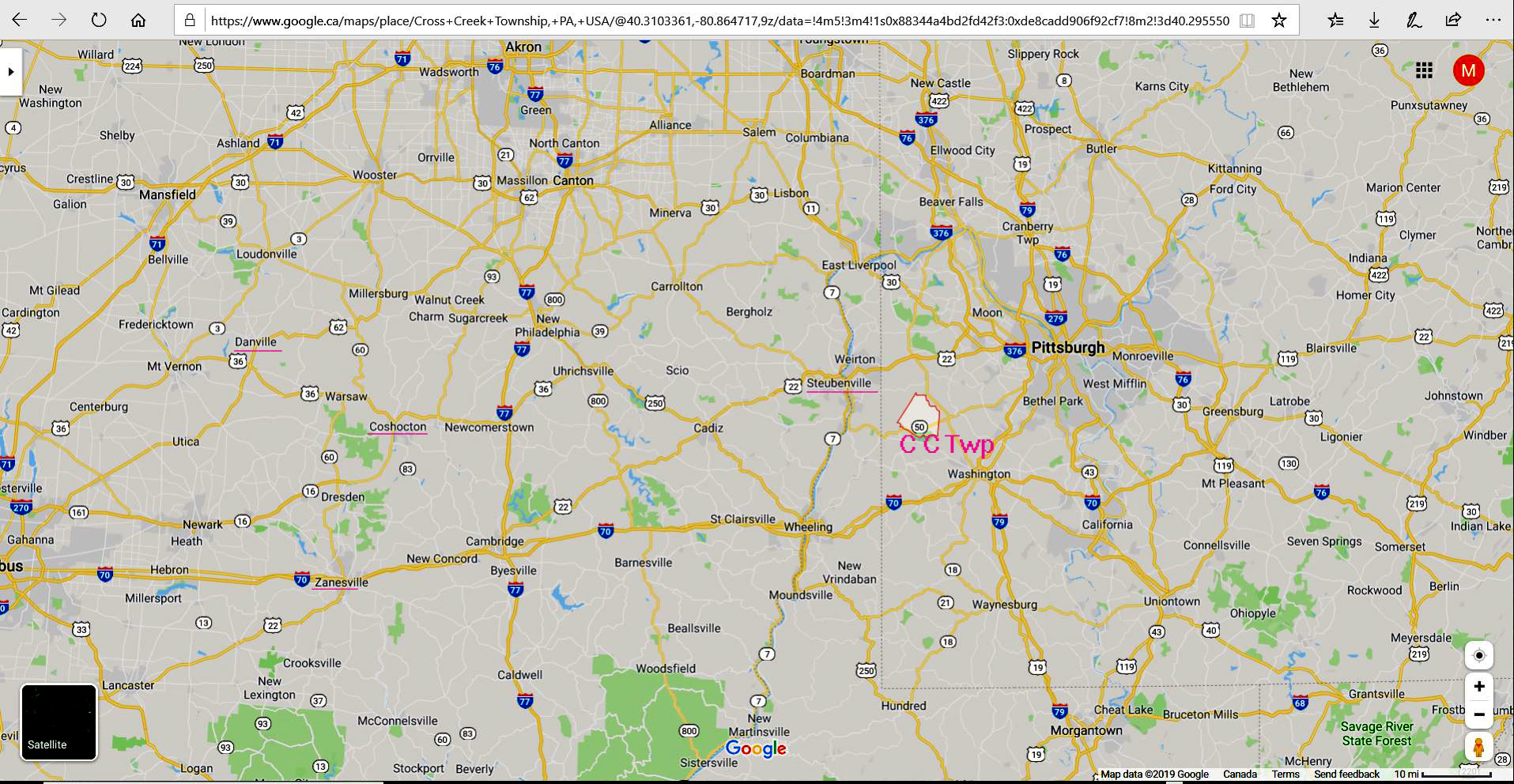
Above right is modern map of Western Pennsylvania and Eastern Ohio. Click on it to open full page! Cross Creek Twp is outlined in red, and marked by the label, C. C. Twp. Steubenville (just across the Ohio River) is underlined. Also underlined are Danville (Knox County) were Charles McKee lived and Coshocton, where Thomas McKee settled. Note our webpage, 1862 Ohio Friendship Quilt, which ties together these families a generation later.
Below is a photo-copy of the 1807 land deed, and a transcription of that deed in italics. Below that is a partial transcription of the 1810 sale. Note – one dollar in 1810 would be worth 21 dollars today.
Transcript of Land Deed, 1807, Jefferson County, Ohio — Galbraith Stewart to Charles McKee
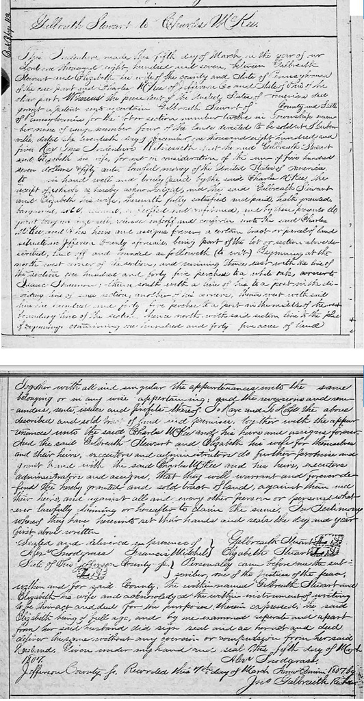
This Indenture made this fifth day of March in the year of our Lord one thousand eight hundred and seven, between Galbraith Stewart and Elizabeth his wife of the county and State of Pennsylvania on the one part, and Charles McKee of Jefferson Co and State of Ohio of the other part. Whereas the president of the United States of America did grant a patent unto a certain Galbraith Stewart of County and State of Pennsylvania for the lot or section number twelve in Township number nine of range number four of the lands directed to be sold at Steubenville dated the seventeenth day of December one thousand eight hundred and five. Now These Indentured Witnesseth that the said Galbraith Stewart and Elizabeth his wife, for and in consideration of the sum of five hundred seven dollars & fifty cents. Lawful money of the United States of America, to xxxx in hand well and truly paid by the said Charles McKee, the receipt of which is hereby acknowledged, and the said Galbraith Stewart and Elizabeth his wife, therewith fully satisfied and paid, hath provided, (four words, separated by commas) and confirmed, and by these present do (six words missing) and confirm unto the said Charles McKee and his heirs and assigns forever, a certain tract or parcel of land situated in Jefferson County aforesaid, being part of the lot or section above described, but off and bounded as followeth (to wit) Beginning at the north west corner of the section, and running thence east with the line of the section one hundred and forty-five perches to a white oak, owner to Isaac Stevenson; thence south with a line of his to a post with the dividing line of said section, another of his owners, thence west with said line one hundred and forty-five perches to a post in the middle of the west boundary line of the section, hence north with said section line to the place of beginning, containing one hundred and forty-five acres of land. Together with all and singular the appurtenances unto the same belonging or in any wise appertaining; and the reversions and xxx, rents, issues and profits thereof. To have and to hold the above described and sold tract of land and premises, together with the appurtenances unto the said Charles McKee and his heirs and assigns forever.
And the said Galbraith Stewart and Elizabeth his wife for themselves and their heirs, executors and administrators do further promise and grant herewith the same of Charles McKee and his heirs, executors administrators and assigns, that they will warrant and forever do their heirs, and against all and every other person or persons whatever lawfully claiming or hereafter to claim the same. In Testimony whereof they have hereunto set their hands and seals the day and year first above written.
Sealed and delivered in presence of Alex Snodgrass, Francis Mitchel, State of Ohio, Jefferson County
Galbraith Stewart, Elizabeth Stewart Personally came before me the subscriber one of the Justices of the Peace, within and for said County. The within named Galbraith Stewart and Elizabeth his wife and acknowledged the within instrument of writing to be their act and deed for the purposes therein expressed , the said Elizabeth being of full age, and by me examined separate and apart from her said husband did sign seal and as her xxx and deed deliver the same without any coercion or compulsion from her saidhusband. Given under my hand and seal this fifth day of March, 1807.Alex Snodgrass, Jefferson County — Recorded this 7th day of March, AD 1807 by Jms. Galbraith, Recorder
Below is a partial transcription of the 1810 land deed, also in italics.
(Partial) Transcript of Land Sale Charles McKee to Samuel Reed 1810
This Indenture made the twenty-seventh day of August in the year of our Lord one thousand and eight hundred and ten by and between Charles McKee and Margaret his wife of Jefferson County and State of Ohio of the one part, and Samuel Reed of the County and State forsaid of the other part – Witnesses that the said Charles McKee and Margaret his wife for and in consideration of ninety dollars to them in hand paid by the said Samuel Reed the receipt whereof is herby acknowledged and the same Charles McKee and Margaret his wife satisfied and paid, both granted, bargained, sold, conveyed and confirmed and do by these presents, grant, bargain, sell, release, convey and confirm unto the said Samuel Reed, his heirs and assigned a certain lot or parcel of land ( situated in Jefferson County aforesaid being part of the lot or section numbered twelve, in Township number nine of the Range numbered four, of the land selected ) to be sold at Steubenville) laid out and bounded as followeth. ( to wit) Beginning at a post in the division line of the said, it being the south east corner of the said Charles McKee’s land and running thence north with the line between Frank Shannon’s land and Charles McKee’s one hundred and forty-six perches to a post in the said line, thence east sixteen and four tenths perches to a post, thence south one hundred and forty-six perches to a post in the said division line of the section, thence west sixteen and four-tenths perches to the place of beginning, containing fifteen acres. To have and to hold to the said Samuel Reed and his heirs and assigns the above described fifteen acres of land with all and singular the appearances these into belonging or ———-
Pioneer Road in Ohio – Zane’s Trace
Colonel Ebenezer Zane, who founded Wheeling, West Virginia, and helped to settle Lancaster, Ohio, appealed to the U. S. Congress for permission to build a road and he received that permission in 1796 after he had already begun the project. Zane requested and received from the American government land grants where the Trace crossed the Muskingum, Hocking and Scioto Rivers to pay for his surveying costs. The government agreed to his request, believing that a major road opened in 1797 would bring more settlers to Ohio and help increase trade.
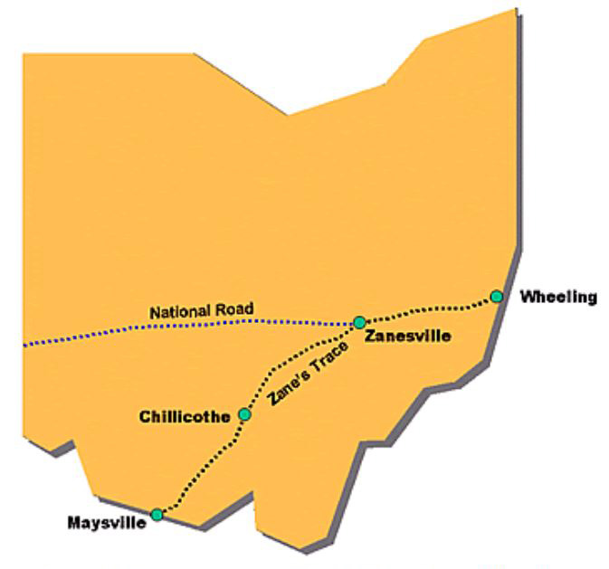
Zane’s Trace was the shortest distance between Wheeling and Limestown, Kentucky (present-day Maysville) on the Ohio River. In the early stages, Zane’s Trace was wide enough for only a horse and rider but not a wagon. Zane built ferries at each of the river crossings, and at the mouth of the Licking River, a town developed, named Zanesville, which is the county seat and largest city in Muskingum County. See map at right for the route of Zane’s trace through south-eastern Ohio
In 1800, the road was widened from Wheeling to Zanesville, but it was steep with deep ruts, making travel difficult. However, the Trace was the only major road in Ohio until after the War of 1812.
In 1803, after Ohio received its statehood, the state legislature set aside money to improve Zane’s Trace and make it accessible by wagon. Trees were cut down to make it 20 feet wide and bridges were built. Soon travel by wagon from Wheeling to Chillicothe was possible. Settlements sprang up along the way, with businesses such as taverns and inns that catered to the travelers. Farmers used the road to transport their crops to market.
The National Road
The National Road (also known as the Cumberland Road) was the first highway built entirely with federal funds. The road was authorized by Congress in 1806 during the Jefferson Administration. Construction began in Cumberland, Maryland on the Potomac river in 1811. At its eastern end, the route closely paralleled the military road opened by George Washington and General Braddock in 1754-55.
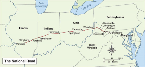
By 1818 the road had been completed to the Ohio River at Wheeling, which was then in Virginia. In eastern Ohio it followed the route of Zane’s Trace, so passed through Zanesville. By 1837, the road was pushed through central Ohio and Indiana reaching Vandalia, Illinois, then then capital of Illinois, 63 miles northeast of St. Louis. Here construction ceased due to a lack of funds but this 620 mile long National Road opened the Ohio River Valley and the Midwest for settlement and commerce. See map at right for the route of the National Road from the east coast to (almost) the Mississippi.
The opening of the National Road saw thousands of travelers heading west over the Allegheny Mountains to settle the rich land of the Ohio River Valley. Small towns along the National Road’s path began to grow and prosper with the increase in population. Towns such as Cumberland, Uniontown, Brownsville, Washington and Wheeling evolved into commercial centers of business and industry. Many small towns and villages along the road contained taverns, blacksmith shops, and livery stables.
Taverns were probably the most important and numerous business found on the National Road. It is estimated there was about one tavern every mile on the National Road. All taverns regardless of class offered three basic things; food, drink, and lodging.
During the heyday of the National Road, traffic was heavy throughout the day and into the early evening. Almost every kind of vehicle could be seen on the road. The two most common vehicles were the stagecoach and the Conestoga wagon. Stagecoach travel was designed with speed in mind. Stages would average 60 to 70 miles in one day.
The Conestoga wagon was the “tractor-trailer” of the 19th Century. Conestogas were designed to carry heavy freight both east and west over the Allegheny Mountains. These wagons were brightly painted with red running gears, Prussian blue bodies and white canvas coverings. A Conestoga wagon, pulled by a team of six draft horses, averaged 15 miles a day. By the early 1850’s technology was changing the way people traveled. The steam locomotive was being perfected and soon railroads would cross the Allegheny Mountains. The people of Southwestern Pennsylvania fought strongly to keep the railroad out of the area, knowing the impact it would have on the National Road. In 1852, the Pennsylvania Railroad was completed to Pittsburgh and shortly after, the B & O Railroad reached Wheeling. This spelled doom for the National Road. As the traffic quickly declined, many taverns went out of business.
Ohio and Erie Canal
Borrowed from Ohio History Central – http://www.ohiohistorycentral.org/w/Ohio_and_Erie_Canal
The Ohio and Erie Canal was one of Ohio’s most important canals during the mid nineteenth century.
During the late 1810s, Governor Thomas Worthington and Governor Ethan Allen Brown both supported internal improvements, especially canals. Both men believed that Ohioans needed quick and easy access to the Ohio River and to Lake Erie if they were to profit financially. Farmers and business owners would be able to transport their products much more easily and cheaply with canals rather than turnpikes. They also hoped that canals would open new markets for Ohio goods.
In 1820, Brown convinced the Ohio legislature to establish the Ohio Canal Commission. Its purpose was to hire an engineer to survey a route for a canal that would connect Lake Erie with the Ohio River. The formation of the board was conditioned on the United States government either donating or selling land to the Ohio government for the canal. The United States government refused, and the Ohio Canal Commission did not complete a survey.
In 1822, the Ohio legislature realized the importance of internal improvements and created a new Ohio Canal Commission. The Commission hired James Geddes, an engineer who had worked on the Erie Canal in New York, to determine the best routes available for a canal from the Ohio River to Lake Erie. Geddes proposed three routes. The Canal Commission eventually recommended a route starting at Lake Erie, passing through the Cuyahoga Valley, the Muskingum Valley, the Licking Valley, and then to the Ohio River along the Scioto Valley. In essence, this first proposed route included a combination of the central and eastern Ohio routes. The Commission also recommended a western route along the Miami and Maumee Valleys. In 1825, the Ohio legislature approved both routes, and work began immediately. On July 4, 1825, at Licking Summit just south of Newark, Ohio Governor Jeremiah Morrow and New York Governor De Witt Clinton, the man most responsible for New York’s Erie Canal, turned over the first shovels of dirt of what would become the Ohio and Erie Canal.
To finance the canals, the Ohio government relied on loans. The legislature established a Canal Fund Commission to regulate the costs of and the securing of money for the canals. Ohio received its initial loan for construction of the canals from bankers and businessmen living along the East Coast. The initial loan was for 400,000 dollars. The canal commissioners estimated that the Ohio and Erie Canal would cost approximately 2.3 million dollars. The Ohio and Erie Canal cost approximately ten thousand dollars per mile to complete. The canals nearly bankrupted the state government, but they allowed Ohioans to prosper beginning in the 1830s all the way to the Civil War.
Canal construction went quickly but not easily. At the peak of construction, more than four thousand workers were laboring on the canals. Private businesses bid on portions of the canals. The state usually accepted the least expensive bids. Once the trench for the canal was dug, workers usually lined it with sandstone. Canal locks also usually consisted of sandstone lined with wood, but sometimes workers made the locks exclusively from wood. The submerged wood would swell, making a waterproof barrier. Workers generally earned thirty cents per day plus room and board. A typical day began at sunrise and did not end until sunset. Many recent immigrants to the United States, especially the Irish, survived thanks to jobs on the canals. Many of Ohio’s communities today, including Akron, began as towns for the canal workers.
Construction was completed in 1832, and by 1833 the Ohio and Erie Canal route was fully operational.
Once completed, the canals still faced numerous difficulties. Flooding could do serious damage to the locks, walls, and towpaths, requiring extensive repairs. Especially in northern Ohio, cold weather would cause the canals to freeze, also causing damage. Usually canals in the northern half of the state were drained dry from November to April. During the winter months, workers would repair any damage that occurred during the earlier part of the year. In southern Ohio, canals generally stayed open the entire year.
The difficulties Ohioans faced with the canals paled in comparison to the advantages that they garnered. Most importantly, the cost to ship goods from the East Coast to Ohio and vice versa declined tremendously from 125 dollars per ton of goods to twenty-five dollars per ton of goods. It took eighty hours to travel from Cleveland to Portsmouth along the Ohio and Erie Canal. While horseback was much quicker, it also cost a great deal more. The cost on the canal boat was $1.70 per person. Most canals remained in operation in Ohio until the late 1800s. There is a short stretch in the Muskingum Valley near Zanesville still in operation today. By the 1850s, however, canals were losing business to the railroads. Railroads had several advantages over the canals, which made the railroads much more popular. While railroads cost more to ship people and goods, they could deliver people and items much more quickly than the canals. Railroads also were not limited by a water source as canals were. Because of these advantages, railroads quickly supplanted the canals.